Jiri
Municipality in Bagmati, Nepal
27.6333°N · 86.2333°E
About
Why visit Jiri
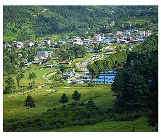
Jiri is a hill town at roughly 1,900 metres in Dolakha District, the traditional starting point for the walk to Everest. Before the airstrip at Lukla opened, expeditions made the long walk in from the roadhead here, and a growing number of trekkers still choose the Jiri route for a slower, greener approach. The town is sometimes called the Switzerland of Nepal for its rolling meadows, pine forests and dairy farms. The trail from Jiri to Lukla crosses a series of river valleys and ridges, climbing and descending repeatedly through Sherpa, Rai and Tamang villages. It adds several days compared with flying to Lukla, but it gives a gentle build-up of altitude, quieter trails and a closer look at everyday hill life before the high mountains appear. Rhododendron forests are at their best in spring. In town you will find a bazaar with basic lodges, a few shops and a cheese factory that dates from the early days of Swiss development projects. Bring your trekking permits and passport, as military or police checks can happen along the road. Getting there: Jiri is reached by road from Kathmandu, a long day on a rough, winding highway by public bus or private vehicle. Plan the walk for spring (March to May) or autumn (October and November), when skies are clearest. The monsoon makes trails muddy and leech-prone, and winter can be cold and snowy at higher points.
Location
Where is it?
Transport
How to get there
All transport options from major cities to Jiri
Transport information coming soon.
Reviews
What travelers say (0)
No reviews yet. Be the first to share your experience.
⚠ Travel Notes
- ·The bus journey from Kathmandu takes 5–7 hours on winding mountain roads and typically arrives in the evening, leaving little daylight for orientation or onward movement
- ·Army checkpoint in town — bags and equipment are subject to search; carry permits and identification accessible, not buried in your pack
- ·The Jiri-to-Namche Bazaar trek is 7–8 days of demanding terrain with significant daily elevation gain and loss; underestimating it compared to the Lukla route is a common mistake
- ·Monsoon season (June–September) makes road access from Kathmandu unreliable due to landslides on the Jiri Highway — delays of many hours or road closures are possible
- ·Altitude at Jiri itself (~1,900m) is manageable, but the trek toward Everest climbs steeply; trekkers flying in from Kathmandu without acclimatization days should plan conservatively
- ·Limited ATM infrastructure — carry sufficient cash from Kathmandu as banking facilities in Jiri and along the classic route beyond are sparse
Explore More
Nearby destinations
Where to stay in Jiri
Compare guesthouses, hotels, and lodges with real-time prices, traveler reviews, and free cancellation on most stays.
More to explore
Other destinations you might like

Patan Durbar Square
Malla-era stone and gilt where Hinduism and Buddhism share the same courtyard
Langtang Valley
The valley of glaciers, closest to Kathmandu

Pashupatinath Temple
Hindu temple in Kathmandu
Kalingchok
Pilgrimage ridge and snow viewpoint at 3,842m